
Underneath all of it is one engine.
Seventeen editions share it: one data fabric, one identity, one agent, 30 shared capabilities built once. Every engine-level improvement built for any edition lands in every other edition in the same release.
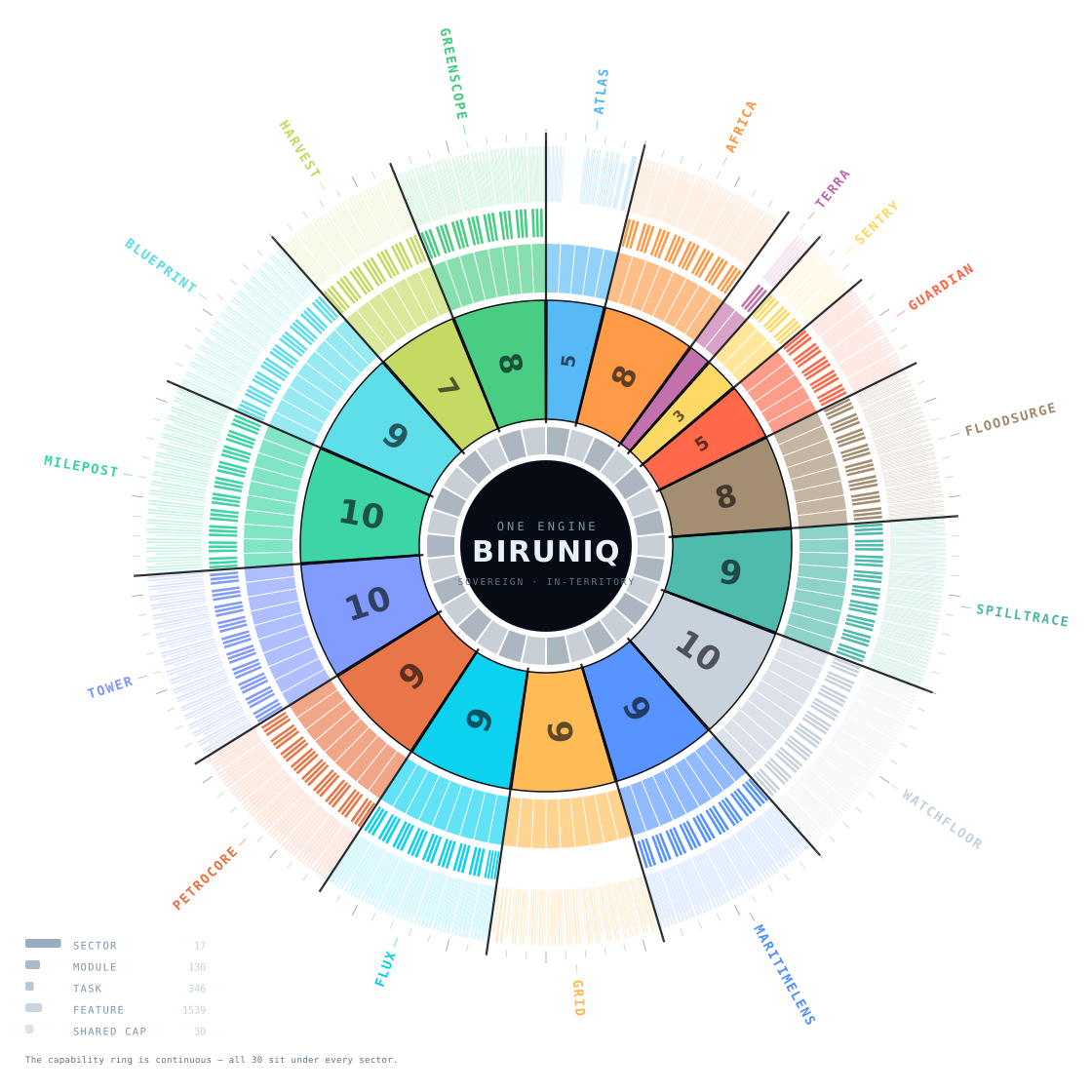
Platform, sector, module, task, feature.
PlatformOne sovereign engine: 30 shared capabilities, one data fabric, one identity, one agent.
Industry editionsA curated catalogue with its own theme, geography and data. All seventeen are live.
Department modulesThe unit a department buys and is held accountable for.
Declared tasksThe use-cases a surface is built to answer. Where a module declares none, the ring shows the gap rather than filling it.
Feature attachmentsAny of the 30 shared capabilities can be cross-added to any module.
Every arc is generated from the engine's own catalogue. Nothing in this diagram is drawn by hand.
One substrate, many owners.
A grant flows down; a denial upstream ends the conversation. Default-deny, down to a single project.
- Container-packaged
- Its own identity provider
- Credentials server-side, write-only
- The licensed editions
- Own tenant, own data, own identity
- The row-level security boundary
- Deny a team a module and no member reaches it
- Whole portfolio or a single project
- Default-deny
- Module-access grid across every edition
- The agent inherits exactly these grants
Five enforcement gates
What appears at all.
Which surfaces resolve.
What the analyst may reason over.
The per-user grant.
Postgres filters the rows themselves.
No separate console.
- 01Provider admin: which modules are enabled across the deployment
- 02Tech admin: module defaults and the shared feature pool
- 03User admin: users, roles and teams
- 04Data sources, each external feed with its status, and one switch for external data
The agent knows who is asking.
Before it answers anything, the agent resolves who is asking (user, tenant, role and groups) and offers only what that grant can reach.
Identity first
Tenant, role and groups are read back to the user in the first reply.
Real functions
The tools are the same calls the interface makes, gated by the same grants.
Refuses, not guesses
An input it cannot act on runs nothing, and the reply says why.
Swappable model
The backbone sits behind an abstract interface; no contract names it.
Built once. Inherited by every edition.
- Live raster overlays: NASA GIBS, ArcGIS REST, STAC
- Team-scoped data via row-level security
- Conversational AI agent control
- Three-tier administration
- Floating, dockable panels
- Sun-position lighting and 3D measurement
- Drawing and annotation tools
- WGS84 · UTM · MGRS · State Plane
- UTM/MGRS grid overlay
- Street-level imagery
- Themeable interface
- Background monitoring daemon
- Multi-modal change detection
- LADM-aligned cadastral fabric
- Geography-aware data registry
- External data-source integration (98)
- Commercial tasking with cost preview
- Point cloud and Gaussian splat rendering
- Print-ready map export
- Mapbook generation
- Module catalogue system
- KPI dashboards
- Categorical and graduated symbology
- Sketch and markup with GeoJSON export
- Live compass rail navigation
- Feature cross-pollination across modules
- Per-user data-source overrides
- Project-level access control
- Analyst-tunable thresholds
- Real-time feature synchronisation
- Sovereignty-enforced deployment
98 registered sources. 17 categories. Each one connection-tested.
The registry is not a list of links. It is the integration programme a customer never has to run, the licence review they never have to repeat, and the silent feed failure they never have to discover in front of a minister.
geoBoundaries · GADM · Overture · OpenStreetMap · OneGeology
WorldPop · JRC GHSL · Kontur · HDX · World Bank · UN Data · Eurostat
GEBCO · EMODnet · GBIF · USGS
NASA FIRMS · OpenAQ · Open-Meteo · GDACS · OpenSky · AIS
NASA GIBS · STAC · Sentinel-1 SAR · Sentinel-2 · VIIRS
Commercial SAR and optical tasking, costed before commitment. Nothing spends without a human.
Sources registered, each an agreement, an endpoint, a schema and a refresh cadence.
Licence breaches by accident: the verdict resolves in code, per module and per scope.
A dead feed is visible: failures surface as a red result to an administrator, not an empty map.
Geography-aware: a national cadastre where one exists, the open continental fabric where it does not.
The last mile is a person, offline.
No-code field apps with offline capture and sync. The inspector's photograph becomes a feature in the department's operating picture without an import step, and without a second system to license.
Five hand-offs. Three days.
- Paper form
- Phone photo
- Email to the office
- Re-key into GIS
- Someone hopes it was the right pole
One hand-off. Minutes.
- Capture in the field, offline
- Syncs on return to coverage
- Appears as a feature in the module: located, permissioned, audited
A field app is a configuration of an existing module, so it inherits that module's permissions and schema.
Capture without connectivity, sync when the vehicle returns to coverage.
No separate field product to license, and no second copy of the asset record to reconcile.
Every capture is located, timestamped and attributed.
What leaves the building.
An operating picture that cannot produce the artefact an agency files is a demonstration, not a system.
- Professional layout composer
- Multi-page mapbook from the live scene
- Print-ready map export
- One-click DOCX incident reports
- GeoJSON export of sketches and markup
- ArcGIS Feature and Map Server, query and upsert
- COG · XYZ raster · GeoJSON URL · PostGIS
- NASA GIBS and STAC as persistable overlays
- Local GeoTIFF and CSV upload
- Floating, snapshot-able panels
- KPI dashboards and the module catalogue
- Point clouds and Gaussian splats
- UTM/MGRS grid and coordinate readout
The city in three dimensions.
Three independent mesh sources render in one scene, and features colour by attribute on both renderers. Coverage is stated: most buildings in the open sources carry no classification, and the legend says so rather than guessing.
What we knew, and when we knew it.
Every incident record carries two clocks: when something was true in the world, and when the system learned it. Corrections supersede; they never overwrite, and that is enforced at the database.
Know where every answer came from.
Every model the platform runs has a manifest entry: source, commit, weight hashes, licence text and fetch date. Anything a model synthesised rather than observed is marked, and the mark follows it to whatever is derived from it.
Built in Rust.
Rust, on Postgres and PostGIS.
A React web client.
A Flutter field app: BirunIQ Field.
Inference in a containerised sidecar, behind an interface, so the model is swappable.
Sign up for platform updates.
Tell us who you are and we'll unlock the six-minute trailer right here, email you the link, and keep you informed as BirunIQ moves toward general availability.